Dredging a main river in May
On May day this year, it was a lovely morning, and being between jobs, I decided to go out for a walk along a local river flooplain.
The hedges were alive with newly arrived and resident birds, and I heard whitethroat, reed warbler and blackcap on my walk. Birds were singing furiously setting up their territories. The hedgerows were covered in spectacular blossom and there were many butterflies on the wing too.
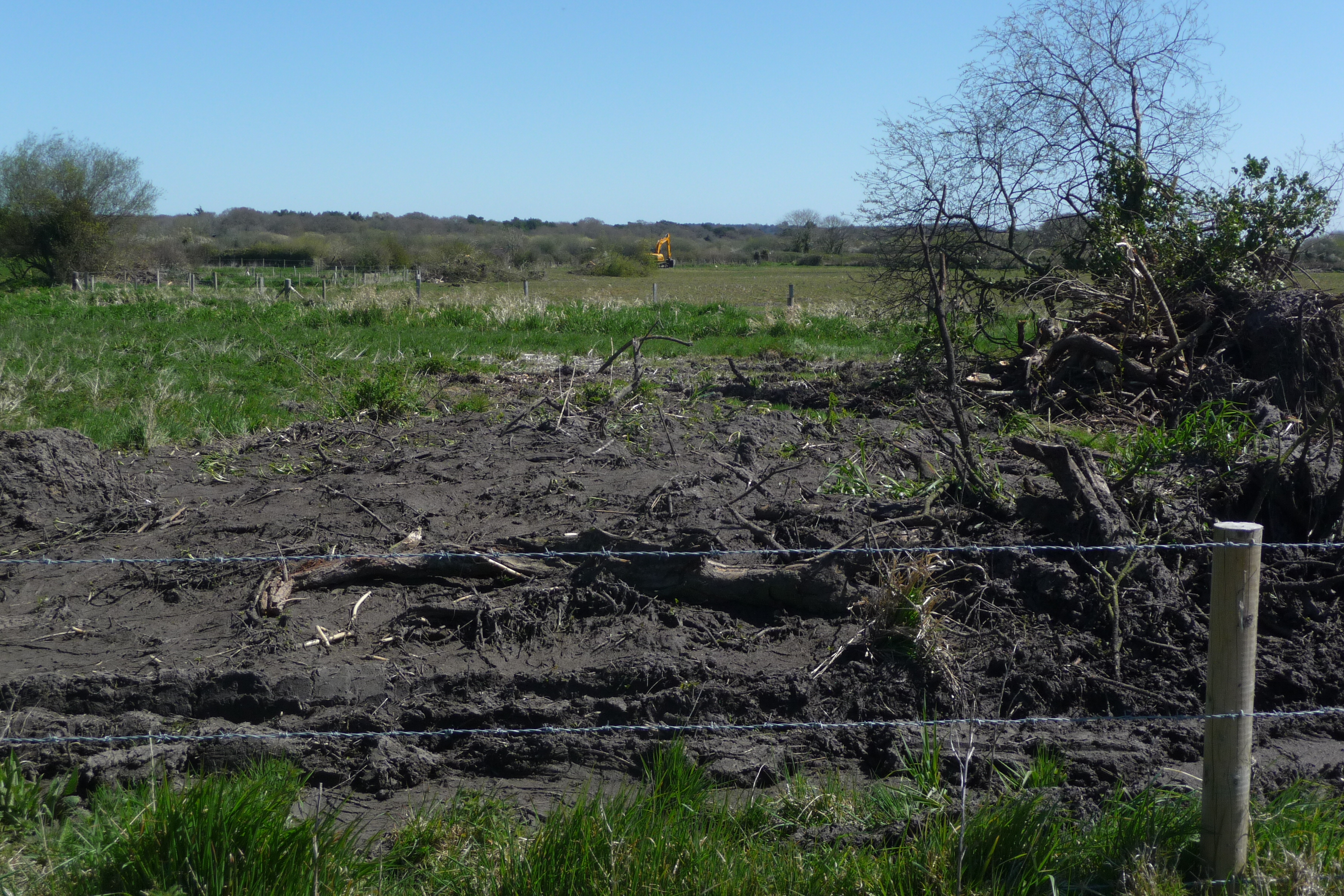
As I crossed the floodplain I was greeted with the scene in the photo above. Large bushes (mainly Goat Willow and Sallow) had been recently removed by a large digger from the river bank, made into a row about 50m long and burnt. There were also great piles of silt along the path. I could hear and see the Slew in the distance – as it continued along the river channel clearing the vegetation.
I was fairly concerned that the work was being done at the wrong time of year, having seen and heard all the bird activity. So I contacted Natural England and the Environment Agency to see whether this work needed approval, and whether approval had been gained.
To their credit EA sent someone out pretty quickly to talk to the farmer. They also informed me that the channel in question was Main River, so consents such as a flood defence consent were needed. It also transpired that a flood defence consent had been applied for by the farmer – I guess he must have known he was going to get the consent so started work anyway.
Here’s the reply from the EA:
“The landowner had been involved in carrying out works within 8mtrs of the ‘main river’ as part of an Flood Defence Consent application filed on March 2013.
During our visit we were able to distinguish two parts of essential maintenance works he had intended to carry out. The former being scrub clearance and removal of fallen trees that normally does not require consent as such, but to do so is considered best practice because we can gauge any impact or give pre-works advice, the latter involving a degree of bank repairs, infilling of cattle drinks and some silt/gravel shoal works which has yet to take place as part of his FDC being granted coincidentally at the time of your report.
In order to confirm that the works were carried out in the spirit of ‘maintenance’ and therefore not regulated as part of his FDC I had was accompanied by our river habitat advisor also based at this office. His comments from our inspection are as follows:
“Re: Farm
I can confirm that following the site visit this afternoon I do not consider the works that we observed on the bank side and in one location within the channel to constitute a potential offence of ‘hydromorphological harm’ as defined under the Water Resources Act 1991 (Amendment) Regulations 2009.
Bank works
The areas of bankside works varied in extent from ~10m to ~ 50m and in these places a number of trees that were impinging on the channel have been removed, together with surrounding scrub vegetation. There was no visible impact on the vertical bank structure, other than very localised areas where a tree had been removed and in these cases the bank had been reformed and compacted to match the adjacent profile. The areas where these works had been carried out had been made good with the top soil redistributed to level the bank slope to match the adjacent unimpacted bank. While these works will have resulted in some loss of diversity within the riparian zone, I do not consider the works of sufficient scale or permanence to result in a deterioration in the WFD status of this waterbody. I would expect these areas to largely revegetate over the coming summer with annual growth, leading to potential scrub and tree growth in future years.
In Channel
In one location it was evident that gravels had been removed from within the channel over a ~ 10m length of bed. This was reportedly done to remove a gravel berm on the right bank that was redirecting flow to the left bank and causing bank erosion. This has locally lowered the centre of the channel bed by ~ 20-30 cm the effect of this is to increase flow velocity in this section of channel. The relatively small scale of the gravel removal, and the ready supply of material from upstream means that the nature of the bed and substrate (WFD quality element) will not change fundamentally and affect WFD status of the water body.
The resultant flow pattern is not unrepresentative of what is seen throughout this part of the River and it is likely that the area of bed that has been lowered will aggrade naturally following high flow events as the readily available gravels are transported from upstream.
Throughout the reach where works have taken place there was no evidence of recent silt deposits smothering gravels”.
Firstly I think it is excellent that not only did EA visit the site so quickly, but also that they provided me with such a comprehensive report of their findings. It was unfortunate to say the least that they inadvertently revealed my personal details to the landowner.
Their view was that removal of mature scrub and even trees from the side of a river channel did not even require consent. That I guess is their perspective as they are looking at the ecological value of the water body, not the ecosystem.
Natural England sent me a standard holding reply to my initial email, then another holding reply in June. I haven’t heard anything from them for a month. I don’t know if they even visited the site.
With this in mind I was interested to read that the Blueprint for Water Coalition was very worried about proposals to move towards allowing landowners to dredge river channels without consent. Blueprint believe this will lead to a ” “triple whammy” of damage to wildlife, increased flooding and potential legal challenges for landowners.”
The issue of who has ultimate oversight of floodplain management is a fraught one, because, as with every other landform, multiple land-uses can be conflicting.
Re-wilding floodplains
Re-wilding has probably the greatest immediate potential within flooplains. And the main reason for that is – of course The Beaver. Amazingly a “wild” beaver has been seen on the River Otter in Devon. How did it get there? Are there more than one – could it be a a family?
If Beavers really did return to the wild – and I think it would be fantastic if they did – where would that leave landowners like the one I encountered in May? Would they feel impunity to remove Beaver dams on the grounds that they were creating flooding problems?
Beaver dams create wetlands which reduce downstream flooding by increasing the storage capacity of the upper floodplain. That wouldnt mean much if you were a farmer watching your potato field turn into a pond.
What if a beaver turned up on a Nature Reserve and started dam-building. That might lead to the loss of high value wetland or wet grassland, or even wet woodland habitat. How would the conservationists there feel – would they be inclined to intervene and move the poor Beavers on. Beavers have a particular penchant for Aspen I understand. Aspen has a rich and threatened invertebrate fauna associated with it. How would the entomologists feel if a Beaver appeared and started felling Aspens that supported the last population of a particular Aspen-living fly.
Yes, while the concept of re-wilding in theory may be simple, the application in practice is not.
(reminds me of one of my favourite Not the Nine O’Clock news sketches with the late great Mel Smith “When I caught Gerald in ’68 he was completely wild; Wild – I was absolutely livid!”

At Alt-Crossens in West Lancashire/North Merseyside we’re to be host to one of the pilots for deemed EA consent; and, complicating matters, the catchment is also one where EA proposes to switch off some of the pumps that have been sustainindg intensive arable and vegetable farming on peatland and sand wedges derived from the large wetland that was the former Martin Mere, once one of England’s largest lakes, though a shallow and seasonal one. Discussions are underway between NFU, EA, NE, Cla and local councils about setting up a trust or Inland Drainage Board to pay the EA to keep pumping. When discussing the pilot for deemed consent we were somewhat sceptical as to what real difference it might make given the EA’s small resource to monitor compliance in any case, even on this catchment that survey suggests is a nationally important area for Water Vole, which begs the further question as to how much the very artificial drainage pattern on this catchment has contributed to that situation! Contrariwise, the limited reduction of pumping that’s already occurred has delivered a wetland nature reserve on the tidal floodplain of the Alt – known as Lunt Meadows. Complicated business, this nature conservation lark. http://www.westlancswildlife.org.uk/index.php?p=1_61_Lunt-Meadows